


Automatic Construction of 3D Cities
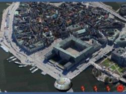 The Challenge: Citymodels are often created by hand making it expensive and time consuming to cover large areas. Now textured 3D models of complete cities at a resolution of 4 inch per pixel can be constructed automatically within days and visualized with the fast BS Contact GEO viewer of Bitmanagement on the web. 3D city models can be integrated in many applications ranging from online search engines to embedded automotive navigation- and entertainment systems. The new technique proves to reduce substantially the creation time and cost of the production process of 3D city models all over the country. Using the new technology, for instance a highly detailed 3D polygonal city model of a complete city of 120 square miles (200 km2 ) can be produced within just 4 days. The data is generated by cameras capturing raster and geometry data.
The Solution: A quality leap hand in hand with a substantial cost reduction can be realized today in the 3D city model domain. Textured 3D models of complete cities at a resolution of 4 inch (10 cm) per pixel can be constructed automatically within days and visualized with the highly performing BS Contact GeoVRML/X3D viewer interactively on the web. 3D city models can be used integrated in many applications ranging from online search engines to embedded automotive navigation- and entertainment systems. In an automated process 3D models are created based on their geo references and saved in VRML/X3D or COLLADA file format. The high quality models e.g. of a complete town or a large industry complex - provided by a content partner of Bitmanagement - are optimised for use on the Internet with tools from Bitmanagement. With the BS Tiler geospatial preparation tool and the new X3D GEO nodes supported in the BS Contact Geo 3D viewer the result can be viewed and navigated interactively on Microsoft, Linux and Apple platforms. Integration of VRML/X3D house models from leading geospatial content providers enhance the experience as users can view buildings at street level or even see the interior of point of interests such as museums, town halls and soccer stadiums. Orbiting around the globe, users can fly seamlessly through satellite images and aerial photographs right down to the textured 3D city without media breaks. At street level the user can enter fully designed 3D models with photo realistic textures and shaders, integrated audio and video content. Bitmanagement cooperates with various content partners to offer content and visualisation software for the specific concept of the application developers. They can define freely their graphical user interfaces, access rules for Intranet/Extranet use as well as the integration to their back end systems. As the software is based on open standards this integration is simple and straight forward. Watch Video at Automated City Visualization For more information please contact Bitmanagement at info@bitmanagement.com