| diagram | 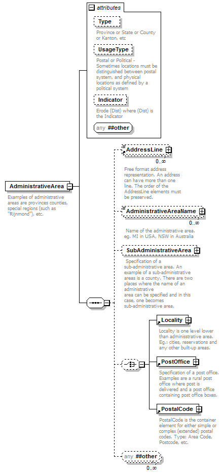 |
||||||||||||||||||||||||||||||
| namespace | urn:oasis:names:tc:ciq:xsdschema:xAL:2.0 | ||||||||||||||||||||||||||||||
| properties |
|
||||||||||||||||||||||||||||||
| children | AddressLine AdministrativeAreaName SubAdministrativeArea Locality PostOffice PostalCode | ||||||||||||||||||||||||||||||
| used by |
|
||||||||||||||||||||||||||||||
| attributes |
|
||||||||||||||||||||||||||||||
| annotation |
|
||||||||||||||||||||||||||||||
| source | <element name="AdministrativeArea"> <annotation> <documentation>Examples of administrative areas are provinces counties, special regions (such as "Rijnmond"), etc.</documentation> </annotation> <complexType> <sequence> <element ref="AddressLine" minOccurs="0" maxOccurs="unbounded"/> <element name="AdministrativeAreaName" minOccurs="0" maxOccurs="unbounded"> <annotation> <documentation> Name of the administrative area. eg. MI in USA, NSW in Australia</documentation> </annotation> <complexType mixed="true"> <attribute name="Type"/> <attributeGroup ref="grPostal"/> <anyAttribute namespace="##other"/> </complexType> </element> <element name="SubAdministrativeArea" minOccurs="0"> <annotation> <documentation> Specification of a sub-administrative area. An example of a sub-administrative areas is a county. There are two places where the name of an administrative area can be specified and in this case, one becomes sub-administrative area.</documentation> </annotation> <complexType> <sequence> <element ref="AddressLine" minOccurs="0" maxOccurs="unbounded"/> <element name="SubAdministrativeAreaName" minOccurs="0" maxOccurs="unbounded"> <annotation> <documentation> Name of the sub-administrative area</documentation> </annotation> <complexType mixed="true"> <attribute name="Type"/> <attributeGroup ref="grPostal"/> <anyAttribute namespace="##other"/> </complexType> </element> <choice minOccurs="0"> <element ref="Locality"/> <element ref="PostOffice"/> <element ref="PostalCode"/> </choice> <any namespace="##other" minOccurs="0" maxOccurs="unbounded"/> </sequence> <attribute name="Type"> <annotation> <documentation>Province or State or County or Kanton, etc</documentation> </annotation> </attribute> <attribute name="UsageType"> <annotation> <documentation>Postal or Political - Sometimes locations must be distinguished between postal system, and physical locations as defined by a political system</documentation> </annotation> </attribute> <attribute name="Indicator"> <annotation> <documentation>Erode (Dist) where (Dist) is the Indicator</documentation> </annotation> </attribute> <anyAttribute namespace="##other"/> </complexType> </element> <choice minOccurs="0"> <element ref="Locality"/> <element ref="PostOffice"/> <element ref="PostalCode"/> </choice> <any namespace="##other" minOccurs="0" maxOccurs="unbounded"/> </sequence> <attribute name="Type"> <annotation> <documentation>Province or State or County or Kanton, etc</documentation> </annotation> </attribute> <attribute name="UsageType"> <annotation> <documentation>Postal or Political - Sometimes locations must be distinguished between postal system, and physical locations as defined by a political system</documentation> </annotation> </attribute> <attribute name="Indicator"> <annotation> <documentation>Erode (Dist) where (Dist) is the Indicator</documentation> </annotation> </attribute> <anyAttribute namespace="##other"/> </complexType> </element> |
attribute AdministrativeArea/@Type
| annotation |
|
||
| source | <attribute name="Type"> <annotation> <documentation>Province or State or County or Kanton, etc</documentation> </annotation> </attribute> |
attribute AdministrativeArea/@UsageType
| annotation |
|
||
| source | <attribute name="UsageType"> <annotation> <documentation>Postal or Political - Sometimes locations must be distinguished between postal system, and physical locations as defined by a political system</documentation> </annotation> </attribute> |
attribute AdministrativeArea/@Indicator
| annotation |
|
||
| source | <attribute name="Indicator"> <annotation> <documentation>Erode (Dist) where (Dist) is the Indicator</documentation> </annotation> </attribute> |
element AdministrativeArea/AdministrativeAreaName
| diagram | 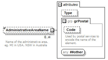 |
||||||||||||||||||||
| namespace | urn:oasis:names:tc:ciq:xsdschema:xAL:2.0 | ||||||||||||||||||||
| properties |
|
||||||||||||||||||||
| attributes |
|
||||||||||||||||||||
| annotation |
|
||||||||||||||||||||
| source | <element name="AdministrativeAreaName" minOccurs="0" maxOccurs="unbounded"> <annotation> <documentation> Name of the administrative area. eg. MI in USA, NSW in Australia</documentation> </annotation> <complexType mixed="true"> <attribute name="Type"/> <attributeGroup ref="grPostal"/> <anyAttribute namespace="##other"/> </complexType> </element> |
attribute AdministrativeArea/AdministrativeAreaName/@Type
| source | <attribute name="Type"/> |
element AdministrativeArea/SubAdministrativeArea
| diagram | 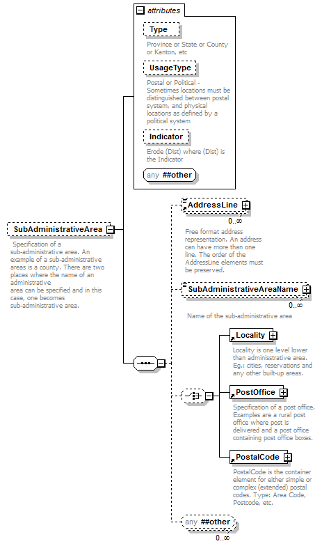 |
||||||||||||||||||||||||||||||
| namespace | urn:oasis:names:tc:ciq:xsdschema:xAL:2.0 | ||||||||||||||||||||||||||||||
| properties |
|
||||||||||||||||||||||||||||||
| children | AddressLine SubAdministrativeAreaName Locality PostOffice PostalCode | ||||||||||||||||||||||||||||||
| attributes |
|
||||||||||||||||||||||||||||||
| annotation |
|
||||||||||||||||||||||||||||||
| source | <element name="SubAdministrativeArea" minOccurs="0"> <annotation> <documentation> Specification of a sub-administrative area. An example of a sub-administrative areas is a county. There are two places where the name of an administrative area can be specified and in this case, one becomes sub-administrative area.</documentation> </annotation> <complexType> <sequence> <element ref="AddressLine" minOccurs="0" maxOccurs="unbounded"/> <element name="SubAdministrativeAreaName" minOccurs="0" maxOccurs="unbounded"> <annotation> <documentation> Name of the sub-administrative area</documentation> </annotation> <complexType mixed="true"> <attribute name="Type"/> <attributeGroup ref="grPostal"/> <anyAttribute namespace="##other"/> </complexType> </element> <choice minOccurs="0"> <element ref="Locality"/> <element ref="PostOffice"/> <element ref="PostalCode"/> </choice> <any namespace="##other" minOccurs="0" maxOccurs="unbounded"/> </sequence> <attribute name="Type"> <annotation> <documentation>Province or State or County or Kanton, etc</documentation> </annotation> </attribute> <attribute name="UsageType"> <annotation> <documentation>Postal or Political - Sometimes locations must be distinguished between postal system, and physical locations as defined by a political system</documentation> </annotation> </attribute> <attribute name="Indicator"> <annotation> <documentation>Erode (Dist) where (Dist) is the Indicator</documentation> </annotation> </attribute> <anyAttribute namespace="##other"/> </complexType> </element> |
attribute AdministrativeArea/SubAdministrativeArea/@Type
| annotation |
|
||
| source | <attribute name="Type"> <annotation> <documentation>Province or State or County or Kanton, etc</documentation> </annotation> </attribute> |
attribute AdministrativeArea/SubAdministrativeArea/@UsageType
| annotation |
|
||
| source | <attribute name="UsageType"> <annotation> <documentation>Postal or Political - Sometimes locations must be distinguished between postal system, and physical locations as defined by a political system</documentation> </annotation> </attribute> |
attribute AdministrativeArea/SubAdministrativeArea/@Indicator
| annotation |
|
||
| source | <attribute name="Indicator"> <annotation> <documentation>Erode (Dist) where (Dist) is the Indicator</documentation> </annotation> </attribute> |
element AdministrativeArea/SubAdministrativeArea/SubAdministrativeAreaName
| diagram | 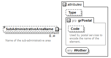 |
||||||||||||||||||||
| namespace | urn:oasis:names:tc:ciq:xsdschema:xAL:2.0 | ||||||||||||||||||||
| properties |
|
||||||||||||||||||||
| attributes |
|
||||||||||||||||||||
| annotation |
|
||||||||||||||||||||
| source | <element name="SubAdministrativeAreaName" minOccurs="0" maxOccurs="unbounded"> <annotation> <documentation> Name of the sub-administrative area</documentation> </annotation> <complexType mixed="true"> <attribute name="Type"/> <attributeGroup ref="grPostal"/> <anyAttribute namespace="##other"/> </complexType> </element> |
attribute AdministrativeArea/SubAdministrativeArea/SubAdministrativeAreaName/@Type
| source | <attribute name="Type"/> |
XML Schema documentation generated by XMLSpy Schema Editor http://www.altova.com/xmlspy