Class GeospatialCoordinateAxesNsewExample
java.lang.Object
Basic.Geospatial.GeospatialCoordinateAxesNsewExample
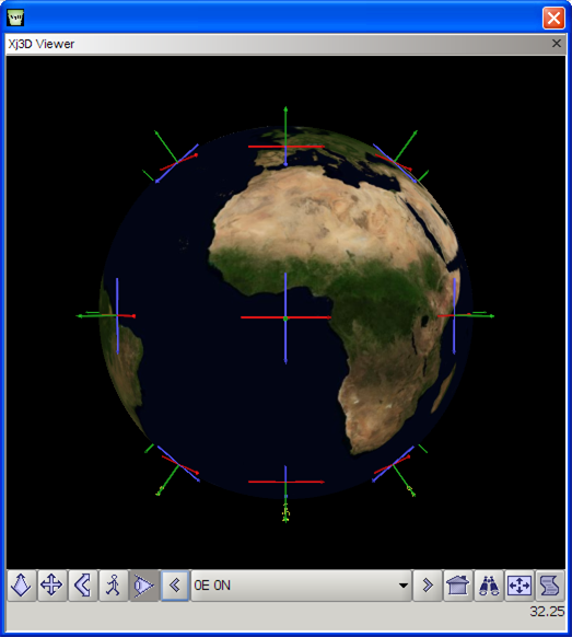
X Y Z axis arrows and labels in Geospatial coordinate system.
Related links: Catalog page GeospatialCoordinateAxesNsewExample, source GeospatialCoordinateAxesNsewExample.java, X3D Resources, X3D Scene Authoring Hints, and X3D Tooltips.
| meta tags | Document Metadata |
| title | GeospatialCoordinateAxesNsewExample.x3d |
| creator | Byounghyun Yoo |
| created | 3 June 2008 |
| modified | 20 October 2019 |
| TODO | fix background globe |
| description | X Y Z axis arrows and labels in Geospatial coordinate system. |
| Image | GeospatialCoordinateAxesNsewExample.png |
| reference | https://www.web3d.org/x3d/content/examples/X3dForWebAuthors/Chapter03Grouping/CoordinateAxes.x3d |
| identifier | https://www.web3d.org/x3d/content/examples/Basic/Geospatial/GeospatialCoordinateAxesNsewExample.x3d |
| generator | X3D-Edit 3.3, https://savage.nps.edu/X3D-Edit |
| license | ../license.html |
This program uses the
X3D Java Scene Access Interface Library (X3DJSAIL).
It has been produced using the
X3dToJava.xslt
stylesheet
(version control)
which is used to create Java source code from an original .x3d model.
-
Constructor Summary
ConstructorsConstructorDescriptionDefault constructor to create this object. -
Method Summary
Modifier and TypeMethodDescriptionorg.web3d.x3d.jsail.Core.X3DProvide a shallow copy of the X3D model.final voidCreate and initialize the X3D model for this object.static voidDefault main() method provided for test purposes, uses CommandLine to set global ConfigurationProperties for this object.
-
Constructor Details
-
GeospatialCoordinateAxesNsewExample
public GeospatialCoordinateAxesNsewExample()Default constructor to create this object.
-
-
Method Details
-
initialize
public final void initialize()Create and initialize the X3D model for this object. -
getX3dModel
public org.web3d.x3d.jsail.Core.X3D getX3dModel()Provide a shallow copy of the X3D model.- Returns:
- GeospatialCoordinateAxesNsewExample model
- See Also:
-
main
Default main() method provided for test purposes, uses CommandLine to set global ConfigurationProperties for this object.- Parameters:
args- array of input parameters, provided as arguments- See Also:
-