
| 1 |
<?xml version="1.0" encoding="UTF-8"?>
|
| 2 |
<!DOCTYPE X3D PUBLIC "ISO//Web3D//DTD X3D 3.3//EN" "https://www.web3d.org/specifications/x3d-3.3.dtd">
|
| 3 | <X3D profile='Immersive' version='3.3' xmlns:xsd='http://www.w3.org/2001/XMLSchema-instance' xsd:noNamespaceSchemaLocation='https://www.web3d.org/specifications/x3d-3.3.xsd'> |
| 4 | <head> |
| 5 | <component level='1' name='Geospatial'/> |
| 6 | <meta name='title' content=' GeospatialCoordinateAxesNsewExample.x3d '/> |
| 7 | <meta name='creator' content='Byounghyun Yoo'/> |
| 8 | <meta name='created' content='3 June 2008'/> |
| 9 | <meta name='modified' content='20 October 2019'/> |
| 10 | <meta name=' TODO ' content=' fix background globe '/> |
| 11 | <meta name='description' content='X Y Z axis arrows and labels in Geospatial coordinate system.'/> |
| 12 |
<meta name='Image' content='GeospatialCoordinateAxesNsewExample.png'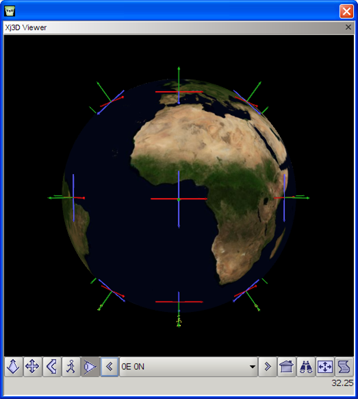 /> />
|
| 13 | <meta name='reference' content=' https://www.web3d.org/x3d/content/examples/X3dForWebAuthors/Chapter03Grouping/CoordinateAxes.x3d '/> |
| 14 | <meta name='identifier' content=' https://www.web3d.org/x3d/content/examples/Basic/Geospatial/GeospatialCoordinateAxesNsewExample.x3d '/> |
| 15 | <meta name='generator' content='X3D-Edit 3.3, https://www.web3d.org/x3d/tools/X3D-Edit'/> |
| 16 | <meta name='license' content='../license.html'/> |
| 17 | </head> |
-->
<!--
![]() DEF nodes index:
CoordinateAxesNSEW,
ORIGIN,
ScaledCoordinateAxesNSEW,
X3D-Earth
DEF nodes index:
CoordinateAxesNSEW,
ORIGIN,
ScaledCoordinateAxesNSEW,
X3D-Earth
| 18 | <Scene> |
| 19 | <!-- X3D Earth is already geospatially referenced --> |
| 20 | <WorldInfo title='GeospatialCoordinateAxesNsewExample.x3d'/> |
| 21 |
<Inline DEF='X3D-Earth'
url=' "http://x3d-earth.nps.edu/d0.x3d" '/>
|
| 22 | <Group> |
| 23 | <!-- Each GeoLocation block shows how to geospatially reference regular nongeospatial shapes --> |
| 24 | <GeoLocation containerField='children'> |
| 25 |
<!-- GeoOrigin
ORIGIN is a DEF node that has 31 USE nodes: USE_1, USE_2, USE_3, USE_4, USE_5, USE_6, USE_7, USE_8, USE_9, USE_10, USE_11, USE_12, USE_13, USE_14, USE_15, USE_16, USE_17, USE_18, USE_19, USE_20, USE_21, USE_22, USE_23, USE_24, USE_25, USE_26, USE_27, USE_28, USE_29, USE_30, USE_31 --> <GeoOrigin DEF='ORIGIN' geoCoords='0 0 -6378137'/> |
| 26 |
<!-- Transform
ScaledCoordinateAxesNSEW is a DEF node that has 25 USE nodes: USE_1, USE_2, USE_3, USE_4, USE_5, USE_6, USE_7, USE_8, USE_9, USE_10, USE_11, USE_12, USE_13, USE_14, USE_15, USE_16, USE_17, USE_18, USE_19, USE_20, USE_21, USE_22, USE_23, USE_24, USE_25 -->
<Transform DEF='ScaledCoordinateAxesNSEW' scale='1000000 1000000 1000000'> |
| 27 |
<Inline DEF='CoordinateAxesNSEW'
url=' "../course/CoordinateAxesNSEW.x3d" "CoordinateAxesNSEW.x3d" "https://www.web3d.org/x3d/content/examples/Basic/course/CoordinateAxesNSEW.x3d" '/>
|
| 28 | </Transform> |
| 29 | </GeoLocation> |
| 30 | <GeoLocation geoCoords='0 45 0' containerField='children'> |
| 31 | <GeoOrigin USE='ORIGIN'/> |
| 32 | <Transform USE='ScaledCoordinateAxesNSEW'/> |
| 33 | </GeoLocation> |
| 34 | <GeoLocation geoCoords='0 89.9 0' containerField='children'> |
| 35 | <GeoOrigin USE='ORIGIN'/> |
| 36 | <Transform USE='ScaledCoordinateAxesNSEW'/> |
| 37 | </GeoLocation> |
| 38 | <GeoLocation geoCoords='0 135 0' containerField='children'> |
| 39 | <GeoOrigin USE='ORIGIN'/> |
| 40 | <Transform USE='ScaledCoordinateAxesNSEW'/> |
| 41 | </GeoLocation> |
| 42 | <GeoLocation geoCoords='0 180 0' containerField='children'> |
| 43 | <GeoOrigin USE='ORIGIN'/> |
| 44 | <Transform USE='ScaledCoordinateAxesNSEW'/> |
| 45 | </GeoLocation> |
| 46 | <GeoLocation geoCoords='0 -45 0' containerField='children'> |
| 47 | <GeoOrigin USE='ORIGIN'/> |
| 48 | <Transform USE='ScaledCoordinateAxesNSEW'/> |
| 49 | </GeoLocation> |
| 50 | <GeoLocation geoCoords='0 -89.9 0' containerField='children'> |
| 51 | <GeoOrigin USE='ORIGIN'/> |
| 52 | <Transform USE='ScaledCoordinateAxesNSEW'/> |
| 53 | </GeoLocation> |
| 54 | <GeoLocation geoCoords='0 -135 0' containerField='children'> |
| 55 | <GeoOrigin USE='ORIGIN'/> |
| 56 | <Transform USE='ScaledCoordinateAxesNSEW'/> |
| 57 | </GeoLocation> |
| 58 | <GeoLocation geoCoords='45 0 0' containerField='children'> |
| 59 | <GeoOrigin USE='ORIGIN'/> |
| 60 | <Transform USE='ScaledCoordinateAxesNSEW'/> |
| 61 | </GeoLocation> |
| 62 | <GeoLocation geoCoords='89.9 0 0' containerField='children'> |
| 63 | <GeoOrigin USE='ORIGIN'/> |
| 64 | <Transform USE='ScaledCoordinateAxesNSEW'/> |
| 65 | </GeoLocation> |
| 66 | <GeoLocation geoCoords='-45 0 0' containerField='children'> |
| 67 | <GeoOrigin USE='ORIGIN'/> |
| 68 | <Transform USE='ScaledCoordinateAxesNSEW'/> |
| 69 | </GeoLocation> |
| 70 | <GeoLocation geoCoords='-89.9 0 0' containerField='children'> |
| 71 | <GeoOrigin USE='ORIGIN'/> |
| 72 | <Transform USE='ScaledCoordinateAxesNSEW'/> |
| 73 | </GeoLocation> |
| 74 | <GeoLocation geoCoords='45 45 0' containerField='children'> |
| 75 | <GeoOrigin USE='ORIGIN'/> |
| 76 | <Transform USE='ScaledCoordinateAxesNSEW'/> |
| 77 | </GeoLocation> |
| 78 | <GeoLocation geoCoords='-45 45 0' containerField='children'> |
| 79 | <GeoOrigin USE='ORIGIN'/> |
| 80 | <Transform USE='ScaledCoordinateAxesNSEW'/> |
| 81 | </GeoLocation> |
| 82 | <GeoLocation geoCoords='45 89.9 0' containerField='children'> |
| 83 | <GeoOrigin USE='ORIGIN'/> |
| 84 | <Transform USE='ScaledCoordinateAxesNSEW'/> |
| 85 | </GeoLocation> |
| 86 | <GeoLocation geoCoords='-45 89.9 0' containerField='children'> |
| 87 | <GeoOrigin USE='ORIGIN'/> |
| 88 | <Transform USE='ScaledCoordinateAxesNSEW'/> |
| 89 | </GeoLocation> |
| 90 | <GeoLocation geoCoords='45 135 0' containerField='children'> |
| 91 | <GeoOrigin USE='ORIGIN'/> |
| 92 | <Transform USE='ScaledCoordinateAxesNSEW'/> |
| 93 | </GeoLocation> |
| 94 | <GeoLocation geoCoords='-45 135 0' containerField='children'> |
| 95 | <GeoOrigin USE='ORIGIN'/> |
| 96 | <Transform USE='ScaledCoordinateAxesNSEW'/> |
| 97 | </GeoLocation> |
| 98 | <GeoLocation geoCoords='45 180 0' containerField='children'> |
| 99 | <GeoOrigin USE='ORIGIN'/> |
| 100 | <Transform USE='ScaledCoordinateAxesNSEW'/> |
| 101 | </GeoLocation> |
| 102 | <GeoLocation geoCoords='-45 180 0' containerField='children'> |
| 103 | <GeoOrigin USE='ORIGIN'/> |
| 104 | <Transform USE='ScaledCoordinateAxesNSEW'/> |
| 105 | </GeoLocation> |
| 106 | <GeoLocation geoCoords='45 -45 0' containerField='children'> |
| 107 | <GeoOrigin USE='ORIGIN'/> |
| 108 | <Transform USE='ScaledCoordinateAxesNSEW'/> |
| 109 | </GeoLocation> |
| 110 | <GeoLocation geoCoords='45 -89.9 0' containerField='children'> |
| 111 | <GeoOrigin USE='ORIGIN'/> |
| 112 | <Transform USE='ScaledCoordinateAxesNSEW'/> |
| 113 | </GeoLocation> |
| 114 | <GeoLocation geoCoords='-45 -89.9 0' containerField='children'> |
| 115 | <GeoOrigin USE='ORIGIN'/> |
| 116 | <Transform USE='ScaledCoordinateAxesNSEW'/> |
| 117 | </GeoLocation> |
| 118 | <GeoLocation geoCoords='45 -135 0' containerField='children'> |
| 119 | <GeoOrigin USE='ORIGIN'/> |
| 120 | <Transform USE='ScaledCoordinateAxesNSEW'/> |
| 121 | </GeoLocation> |
| 122 | <GeoLocation geoCoords='-45 -135 0' containerField='children'> |
| 123 | <GeoOrigin USE='ORIGIN'/> |
| 124 | <Transform USE='ScaledCoordinateAxesNSEW'/> |
| 125 | </GeoLocation> |
| 126 | <GeoLocation geoCoords='-45 -45 0' containerField='children'> |
| 127 | <GeoOrigin USE='ORIGIN'/> |
| 128 | <Transform USE='ScaledCoordinateAxesNSEW'/> |
| 129 | </GeoLocation> |
| 130 | <GeoViewpoint description='0E 0N' fieldOfView='1.05' orientation='1 0 1 -1.5707' position='0 0 10000000' containerField='children'> |
| 131 | <GeoOrigin USE='ORIGIN'/> |
| 132 | </GeoViewpoint> |
| 133 | <GeoViewpoint description='90E 0N' fieldOfView='1.05' orientation='1 0 1 -1.5707' position='0 89.900002 10000000' containerField='children'> |
| 134 | <GeoOrigin USE='ORIGIN'/> |
| 135 | </GeoViewpoint> |
| 136 | <GeoViewpoint description='90W 0N' fieldOfView='1.05' orientation='1 0 1 -1.5707' position='0 -89.900002 10000000' containerField='children'> |
| 137 | <GeoOrigin USE='ORIGIN'/> |
| 138 | </GeoViewpoint> |
| 139 | <GeoViewpoint description='180E 0N' fieldOfView='1.05' orientation='1.0 0.0 0.0 -1.5707' position='0 180 10000000' containerField='children'> |
| 140 | <GeoOrigin USE='ORIGIN'/> |
| 141 | </GeoViewpoint> |
| 142 | <GeoViewpoint description='North Pole' fieldOfView='1.05' orientation='1.0 0.0 0.0 -1.5707' position='90 0 10000000' containerField='children'> |
| 143 | <GeoOrigin USE='ORIGIN'/> |
| 144 | </GeoViewpoint> |
| 145 | <GeoViewpoint description='South Pole' fieldOfView='1.05' orientation='1.0 0.0 0.0 -1.5707' position='-89.9 0 10000000' containerField='children'> |
| 146 | <GeoOrigin USE='ORIGIN'/> |
| 147 | </GeoViewpoint> |
| 148 | </Group> |
| 149 | </Scene> |
| 150 | </X3D> |
-->
<!--
![]() DEF nodes index:
CoordinateAxesNSEW,
ORIGIN,
ScaledCoordinateAxesNSEW,
X3D-Earth
DEF nodes index:
CoordinateAxesNSEW,
ORIGIN,
ScaledCoordinateAxesNSEW,
X3D-Earth
<!--
Online at
<!--
Color-coding legend: X3D terminology
<X3dNode DEF='idName' field='value'/>
matches XML terminology
<XmlElement DEF='idName' attribute='value'/>
(Light-blue background: event-based behavior node or statement)
(Grey background inside box: inserted documentation)
(Magenta background: X3D Extensibility)
-->
![]() <!--
For additional help information about X3D scenes, please see X3D Tooltips, X3D Resources, and X3D Scene Authoring Hints.
-->
<!--
For additional help information about X3D scenes, please see X3D Tooltips, X3D Resources, and X3D Scene Authoring Hints.
-->